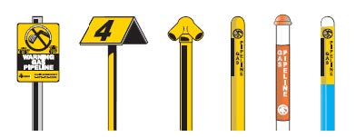
Permanent Pipeline Markers
Operators place signs and markers along the pipeline route to identify the general location of a pipeline and specify the type of product transported, the operator’s name and an emergency contact number. Pipeline markers do not identify the exact location of a pipeline and should not be used to locate pipelines prior to excavation.
If you are responding to a 911 call about a strange odor or leak, find a pipeline marker or sign to identify the pipeline product and operator.

Pipelines Nearby Application
This application provides the approximate pipeline location information along with general hazard recognition and response information for five pipelines closest to a specific location. However, it does not contain information for all member pipelines, only the members who have supplied information. Click the button below to access the application.
Pipeline Maps
The U.S. Department of Transportation’s Pipeline and Hazardous Materials Safety Administration (PHMSA) provides online maps to help you locate pipelines in or near your community through the National Pipeline Mapping System (NPMS). Maps generated by NPMS show the approximate location of gas and hazardous liquids transmission pipelines in relation to specific addresses, major roads, zip codes, cities and counties. NPMS does NOT include gathering or distribution pipelines. Some states regulatory agencies also provide maps showing the general location of pipelines in their state.
You can use NPMS to obtain contact information for transmission pipeline operators. Operator contact information typically includes the operator’s name, product transported, contact name and phone number. A summary of active mileage by county in xlsx format is available from their General Public Page. The file that was current as of 2-23-2023 is available here. It contains an additional summary table that can be expanded to show mileage for each product at the county level.
Learn more about the types of pipelines that make up our nation’s pipeline infrastructure.
Watch a short video to learn more about NPMS.
Remember to always call 811 or your local One-Call center to have pipelines located and marked before digging.

PipeVision Application
PipeVision provides emergency response agencies detailed information about pipelines in their jurisdiction including an initial evacuation distance from the line during and emergency. The application also includes a mechanism for agencies to collaborate with pipeline operators by submitting information regarding populated areas (identified sites) near these pipelines. Access to PipeVision will only be given to emergency response agencies.


